
Nepal-Tibet Flood Disaster: Death Toll Exceeds 1,000 as Rescuers Race to Reach Trapped Hydropower Workers
KATHMANDU — A week after a glacier collapse unleashed a wall of water, mud and rock down a Himalayan river valley straddling the Nepal-China border, the confirmed death toll has surpassed 1,000, with more than 4,400 people still missing. Rescue teams are focused on freeing hundreds of hydropower workers feared trapped inside collapsed tunnels in Nepal's Rasuwa and Nuwakot districts.
The disaster began on the morning of August 26, when a glacial collapse above Tibet's Lhende Khola triggered a magnitude 5.2 seismic signal. The event caused a glacial barrier lake to fail, sending a surge of water and debris through the Bhotekoshi River into Nepal's Rasuwa district, then downstream along the Trishuli and Narayani rivers over the following hours.
Nepal's National Disaster Risk Reduction and Management Authority (NDRRMA) reports 987 confirmed deaths within Nepal as of September 1, with 3,916 people listed as missing. China's Tibet Autonomous Region has confirmed 16 additional deaths and 546 missing. More than 11,800 people have been rescued so far.
Hundreds trapped in tunnels
A significant portion of the rescue effort is now focused on roughly 600 workers unaccounted for across 11 hydropower project sites in the affected districts. Rescuers — including teams from Nepal, China, and India — are using heavy machinery, temporary bridges, and oxygen-pumping equipment to reach people believed trapped in underground tunnels and buried infrastructure.
Authorities confirmed that 279 workers had been rescued from the tunnels as of late Monday, with operations ongoing. The trapped workforce includes Nepali, Indian, and Chinese nationals, according to officials familiar with the projects.
The hydropower sites, built along the fast-flowing river corridors of the Nepal Himalaya, were particularly vulnerable to the sudden surge of water and debris. Video footage from the disaster showed a several-stories-high torrent sweeping through communities and industrial installations with little warning.
Warnings were raised months earlier
On May 27 — three months before the disaster — officials and experts from Nepal and China met in Kathmandu to discuss disaster risks in the border area. The meeting covered flood and glacier-related threats, as well as monitoring and response strategies, according to a meeting agenda reviewed by Reuters.
Satellite imagery from the weeks and days before the collapse reportedly revealed early warning signs of glacier instability. The US Geological Survey later confirmed that the initial seismic signal, briefly mistaken for an earthquake, was in fact a glacial collapse and debris flow that caused "catastrophic downstream impacts."
Some local residents say word-of-mouth communications and improvised early warnings saved hundreds of lives on the morning of August 26, though the speed and scale of the flood overwhelmed many communities along the 72-kilometer stretch of the Trishuli River corridor.
Widespread destruction
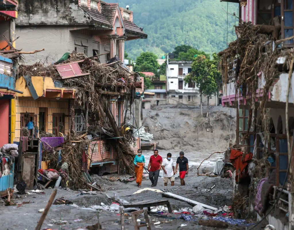
Entire neighborhoods in the border settlements of Timure and Syabrubesi were buried under water and mud. The flood destroyed 18 schools outright and damaged at least 20 more, disrupting education for thousands of students. The primary highway connecting Kathmandu to the Chinese border at Kerung remains cut off in multiple sections.
The Nepalese government has placed five districts on high alert and appealed for international assistance. Prime Minister Balendra Shah has called for greater climate action, pointing to the disaster as evidence of accelerating glacial instability across the Himalaya.
China's President Xi Jinping has ordered intensified efforts to find survivors, and Chinese DNA testing experts are being dispatched to affected areas to assist in identifying victims.
A worsening pattern
The floods struck areas still recovering from disasters in 2024 and 2025, underscoring a deteriorating cycle of natural disasters and costly reconstruction across Nepal's mountain regions. Scientists warn that as Himalayan glaciers continue to weaken under warming temperatures, similar glacial lake outburst floods and glacier collapses are likely to become more frequent.
A newly formed barrier lake along the Bhotekoshi River is raising concerns about potential further flooding. Satellite imagery and drone footage have prompted a "major risk" warning from a glacier that could pose a new threat to downstream communities.
Climate researchers note that while investigations into the precise mechanisms of this disaster are still underway, long-term warming trends and the infrastructure built in vulnerable river valleys are compounding factors.