
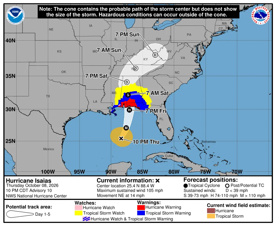
Hurricane Isaias strengthened into a Category 2 storm with 100 mph winds, becoming the first hurricane of the 2026 Atlantic season as the northern Gulf Coast braces for landfall late Friday or early Saturday.
Hurricane Isaias intensified into a Category 2 storm on Thursday, becoming the first hurricane of the 2026 Atlantic season and setting up a dangerous landfall along the northern U.S. Gulf Coast expected late Friday night or early Saturday.
The National Hurricane Center reported that Hurricane Hunter aircraft found maximum sustained winds had increased to near 100 mph, with higher gusts. The storm was moving east-northeast at roughly 9 mph before an expected turn toward the north.
Where Isaias Is Headed
Forecasters expect Isaias to make landfall along a stretch spanning parts of Mississippi, Alabama and the western Florida Panhandle. The latest forecast calls for landfall near the Florida-Alabama border, though the NHC cautions that the track could shift up to the last minute.
The storm is projected to reach near-major-hurricane strength before coming ashore, with sustained winds approaching 110 mph — just below the 111 mph threshold for Category 3. Rapid intensification remains possible, forecasters said.
Watches and Warnings
The National Hurricane Center has issued the following:
- Storm Surge Watch: from the mouth of the Mississippi River to Yankeetown.
- Hurricane Watch: from Bay St. Louis to Indian Pass.
- Tropical Storm Watch: from the Jefferson/Plaquemines Parish line to west of Bay St. Louis, and from east of Indian Pass to the Aucilla River.
Evacuations and Preparation
Mandatory evacuations and school closures have been ordered in parts of Florida as coastal communities prepare. Emergency crews beyond the immediate strike zone are also mobilizing, with Kentucky officials readying response teams.
Forecasters are urging residents from Louisiana to the Florida Panhandle to finalize preparations rather than wait to see how strong the storm becomes.
Expected Impacts
The primary threats include:
- Storm surge: Water could reach 5 to 7 feet above ground in parts of Alabama and Mississippi, with surge of up to 10 feet possible in some areas. A combination of surge and high tide could flood normally dry areas near the coast.
- Rainfall: 3 to 7 inches along the central Gulf Coast from southeast Louisiana to the Florida Panhandle, with localized totals up to 10 inches.
- Wind and tornadoes: Damaging winds and a risk of tornadoes are expected as the storm approaches.
Swells are forecast to affect the western and northern Yucatan Peninsula beginning Thursday before spreading north toward the Gulf Coast later in the week.
Why It Matters
Isaias formed as a tropical storm on Oct. 7, the ninth named storm of the season, leaving coastal residents little time to prepare. A strengthening hurricane can leave communities with very little margin for error, and conditions can deteriorate quickly as the storm nears the coast.
Residents in the watch areas should monitor updates from the National Hurricane Center and local emergency officials as the forecast is refined.